Check out the video below from the Institute For Transport Studies @ The University Of Leeds
New Release: Travel Modes, Map Types and more
We are happy to announce a new Tripline release with a bunch of new functionality that we think you’ll love. Read on for the details, or head over to www.tripline.net and create a new map.
Travel Modes, Insert After & Custom Points
In the Tripline Editor, You can now click on the individual lines in your maps and set a travel mode. The options are:
1. Direct (straight line, default, good for flights)
2. Driving (line will follow recommended driving route)
3. Transit (line will follow rail/bus paths)
4. Bicycle (line will follow known bike routes / paths)
5. On Foot (line will follow known foot routes / trails)
6. Custom (you can manually adjust the line)
You’ll also notice an [ADD INTERMEDIATE WAYPOINT] button. That allows you to add a new waypoint in-between the two points on a line. Use this button if you want to have your path go through a specific city/town/intersection. Paths will update automatically.
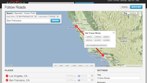
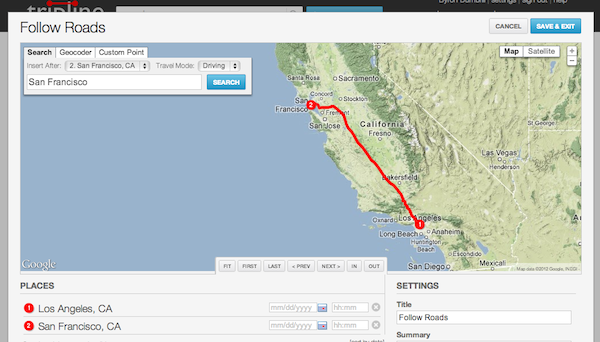
You can also choose travel mode before adding a place by selecting [Travel Mode] from the dropdown above the search box. When you do this, the chosen mode will remain selected so all subsequent lines will get the same mode until you change it. This is a nice easy way to create road trips very quickly.

Another new addition to the search box is the [Insert After] dropdown list. This is a list of all the points in your map and you can use it to position new places in your list so you don’t have to add them to the bottom and then drag/drop.

You’ll also notice that we’ve changed the Custom Point section of the place search box. You can either paste in decimal lat/lng coordinates or click the [DROP POINT] button to drop a new point on the map wherever you want.

Map Types
You can now select a Map Type in the editor to display a different type of map. The default map type is still Terrain, but you can now turn off Terrain to display a regular Roadmap or choose Satellite mode.

Road maps and Satellite allow deeper zoom levels than Terrain, so they’re really useful for things like pub crawls, city walks and hikes where you want a lot of detail.
Player Updates
Based on your feedback, we’ve made some changes to the player to improve the playback experience.
1. Explore view by default – the player used to display a big play button when first loaded. Now the big play button is gone and you can hover over the places in your map right away. To start the animation, click the smaller blue play button at the upper right
2. Clickable links – Links in your place info are now clickable.
3. No delay on slideshows – When you set a place to slideshow mode, the photos will now start to display right away instead of displaying the place popup first.
Here are a few examples so you can see the new stuff in action:
LA Pub Crawl
Runyon Canyon Hike
Alamere Falls Day Trip
More New Features
We’ve also added a few new features in other areas of the site
1. Private user profiles – On your settings page, you can now select a checkbox to set your profile page to “Private”. This means that your profile page will only be visible to friends and it won’t be indexed by search engines.
2. Change your username – On your settings page, you can now change your username. This will also update the vanity url for your page.
3. Resizable maps – You can now resize the map in the Tripline editor. Just click and drag on the bottom edge of the map.
4. Full-width site – The Tripline site will now expand to fill your browser window
Bug Fixes
– Facebook Connect, Facebook App and Facebook photos are now working correctly
– Bug with Tripit Import putting places in the wrong location has been fixed
– Saving place info and uploading photos on the map page is now updating the player as expected
– Embedded videos will now be displayed without having to refresh the page
– We now support the new youtu.be links from YouTube
– You can now remove your profile photo on your settings page
Thanks as always for being part of Tripline and send an email to support@tripline.net if you have any questions, or add a comment below.
Enjoy!
– Byron & the Tripline Team
Mapping Space Shuttle Endeavor’s Final Journey
Newsmappers has created a great map of the Space Shuttle Endeavor’s final journey to Los Angeles, including photos and videos from the cross-country trip, the epic flyover of California landmarks and details of the overland route from LAX to the California Science Center next month. Check it out:
New Release: Facebook friend map on main site, performance improvements
We just launched a small release tonight with a few notable features:
- We added the Facebook friend map to the main site (previously it was only available in our Facebook app). If you’ve connected your Tripline account to Facebook, you’ll now see a [Load Friend Map] button on the logged in home page. Click on this to display a map of your Facebook and Tripline friends, including:
- Latest checkins around the globe
- Tripline maps in progress
- All Tripline maps with friends
- Where your Facebook friends live now
- Where your Facebook friends grew up
- We changed the activity feed on the home page to load asynchronously (you know, the “Loading…” text with a spinner). Our activity feed is getting pretty active these days, so loading asynchronously will speed up initial page load time quite a bit.
- The mobile app now loads your past 25 maps instead of 15
- We also fixed several other small bugs
That’s it for now. We’re continuing to work on more features, so as always, email support@tripline.net if there’s something you’d like us to do, or if you’re having any trouble.
Byron
Import from Instagram, import photos from Foursquare, photo galleries and comments in the iPhone & iPad app, and more
We’re starting off 2012 by adding some great new features to Tripline.
Instagram Import
Now you can connect your Instagram account to Tripline and import your photos to automatically create maps. It’s another great way to tell your stories.
Click [Create A New Map] and then click [Create A Map Of My Photos]
We’ll load the 20 most recent photos from your Instagram feed. You can click [+] load more at the bottom of the list to add additional photos. There’s no limit.
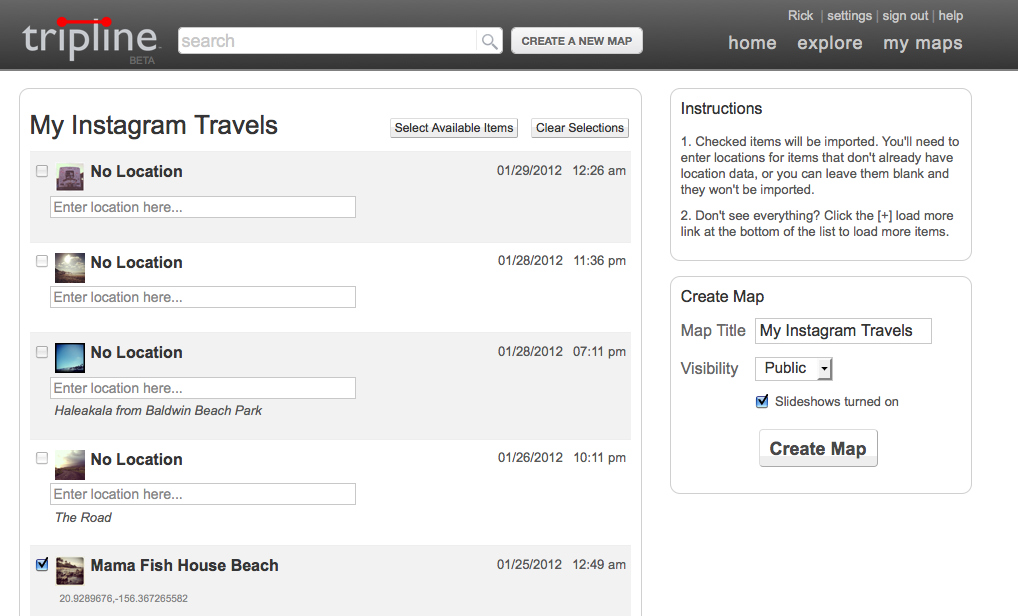

Only checked items will be imported. For unchecked items that don’t have location data use the search box to type in, select and add a location. If left unchecked the images will not be added the map.
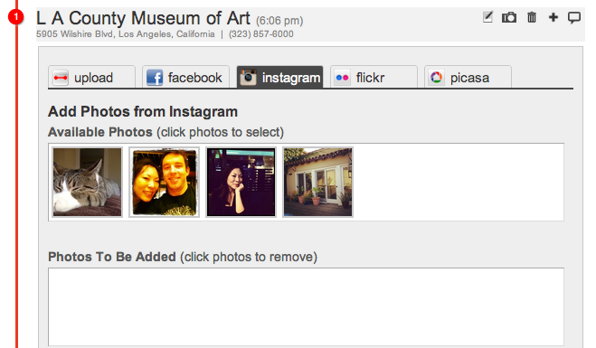
You can also add Instagram photos to existing maps. On the map page, click on the camera icon next to each waypoint and choose the Instagram tab.
Foursquare Photos
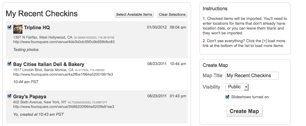
You’ve been requesting this feature for a while and we’ve been listening! This release includes the ability to include your Foursquare pictures when you create a map from checkins.
.
iPhone/iPad App & Mobile Site
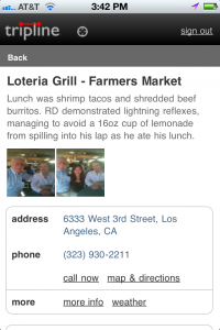
- Now you can view a gallery of your photos in your maps right on your phone! Photo upload is still limited to the iPhone/iPad app, but photo display is available on all devices.
- You can now read and create comments on the mobile site and iPhone/iPad app. Remember, comments can be on the trip itself, or each individual waypoint.

Performance Improvements
- Improved Map Player Loading Time: We noticed map loading times were a bit slow when the maps had a lot of points and pictures. So, we did some work and now you don’t have to watch the spinning wheel for longer than a second or two.
Thanks a lot for being a part of Tripline. As always, if you need help with something, please email us: support@tripline.net